|
YOZGAT |
City Information
 217 kms from
Ankara is Yozgat, whose history extends as far back as the Hittite period. It
was an important residential area in those times, and Alisar, one of the main
Hittite cities, lies inside the borders of this province. Bogazkoy and
Alacahoyuk, though not being part of Yozgat, are near
217 kms from
Ankara is Yozgat, whose history extends as far back as the Hittite period. It
was an important residential area in those times, and Alisar, one of the main
Hittite cities, lies inside the borders of this province. Bogazkoy and
Alacahoyuk, though not being part of Yozgat, are near
 enough to reflect the
central position of the site with the notable ruins found in the district.
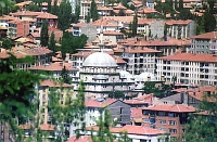
Today's city of Yozgat, on the other hand, is rather new, founded in the 18th
century by the Ottomans. Capanoglu Ahmet Pasa, who was the "Bey" of the Turkmens
at that time was the founder; and the Capanoglu Mosque which carries his name,
stands as a remnant of this period along with the Suleyman Bey Mosque.
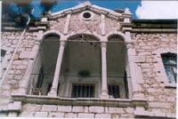
Constructed in the 19th century, the Nizamoglu Mansion is a prominent building,
displaying a fine Turkish architectural style. It is an important house of the
Ottoman period and is now used to exhibit ethnographical treasures. Near Yozgat,
"Camlik" is an islet of forests. This site is a national park, 5 km south of the
city, adorning the land with its beautiful scenery.
enough to reflect the
central position of the site with the notable ruins found in the district.
Today's city of Yozgat, on the other hand, is rather new, founded in the 18th
century by the Ottomans. Capanoglu Ahmet Pasa, who was the "Bey" of the Turkmens
at that time was the founder; and the Capanoglu Mosque which carries his name,
stands as a remnant of this period along with the Suleyman Bey Mosque.
Constructed in the 19th century, the Nizamoglu Mansion is a prominent building,
displaying a fine Turkish architectural style. It is an important house of the
Ottoman period and is now used to exhibit ethnographical treasures. Near Yozgat,
"Camlik" is an islet of forests. This site is a national park, 5 km south of the
city, adorning the land with its beautiful scenery.
text reference : www.anatolia.com
Local Weather Condition
| Latitude(° ' ) | Longitude(° ' ) | PoR (year) | E (m) | M C (0-10) | M H (%) | MRF (mm) | DwR | PWD | MWS (m/sn) | H T (°C) | M Tmax (°C) | M Tmin (°C) | L T (°C) | M T (°C) | DwS | DwoS |
|---|---|---|---|---|---|---|---|---|---|---|---|---|---|---|---|---|
| 39 49 | 34 48 | 40 | 1298 | 6.6 | 72 | 70.4 | 14.2 | WSW | 3.2 | 25 | 7.4 | -1.8 | -20 | 2.5 | 3.6 | 12.4 |
| PoR : Period of Record (year) | E : Elevation (m) | M C : Mean Cloud (0-10) | M H : Mean Humidity (%) |
| M R F : Mean Rain Fall (mm) | DwR : Days with rain | PWD : Prevail wind direction | MWS : Mean wind speed (m/sn) |
| H T : Highest T (°C) | M Tmax : Mean Tmax (°C) | M Tmin : Mean Tmin (°C) | L T : Lowest T (°C) |
| M T : Mean T (°C) | DwS : Days with Sun | DwoS : Days without Sun |
![]()