|
TOKAT |
City Information
 A culturally
rich settlement center, with traces of history all over the land, Tokat lies
inland of the middle Black Sea region, 422 kms from Ankara. Wandering in the
city is an opportunity to catch a glimpse of life at old times, with the many
historical buildings at the numerous ancient sites. The most important figure
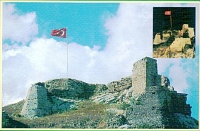
here, is the Ottoman Citadel of 28 towers, founded on a rocky hill overlooking
the town. The Garipler Mosque dating to the 12th century and the Ali Pasa Mosque
of 16th century constitute other sights worth visiting. One of Tokat's finest
buildings is the Gok Medresse (Pervane Bey Darussifasi) which was constructed in
1270. It was founded as a school of theology, and is now converted into a
museum, housing archaeological finds from the area. Two other notable monuments
in this region, are the Hatuniye Medresse of the 15th century, built by Sultan
Beyazit, and a Seljuk bridge spanning the Yesilirmak River,
 belonging to the
12th century. The Latifoglu Mansion is still another, which is a traditional
Turkish house of the 19th century, restored recently to its original state. 69
kms northeast of Tokat, is Niksar, one of the beautiful towns of the province,
which carries important signs from the history of the country. It was once the
capital of the Turkish Danismend Emirs, and among the interesting sights are the
well-preserved citadel, the Ulu Mosque, and the 12th century Yagbasan Medresse.
Zile is another ancient town, 67 kms west of the province, with its fortress and
the 13th century Ulu Mosque near it. This district has been the scene of many
events of the earliest ages too, and it was here that the Roman Emperor Julius
Caesar said his famous words "Veni, Vidi, Vici"; "I came, I saw, I conquered".
Resadiye is well known for its vast pine forests, hot springs, clays and natural
beauties. Ballica cave at Pazar is a natural wonder. The Dumanli meadows are the
other famous places for resting and refreshing.
text reference : www.anatolia.com
Local Weather Condition
| Latitude(° ' ) | Longitude(° ' ) | PoR (year) | E (m) | M C (0-10) | M H (%) | MRF (mm) | DwR | PWD | MWS (m/sn) | H T (°C) | M Tmax (°C) | M Tmin (°C) | L T (°C) | M T (°C) | DwS | DwoS |
|---|---|---|---|---|---|---|---|---|---|---|---|---|---|---|---|---|
| 40 19 | 36 33 | 5 | 585 | 6.7 | 65 | 48.1 | 12.8 | SW | 2.9 | 26.2 | 13.3 | 2.1 | -6.6 | 7.4 | 4.2 | 13.4 |
| PoR : Period of Record (year) | E : Elevation (m) | M C : Mean Cloud (0-10) | M H : Mean Humidity (%) |
| M R F : Mean Rain Fall (mm) | DwR : Days with rain | PWD : Prevail wind direction | MWS : Mean wind speed (m/sn) |
| H T : Highest T (°C) | M Tmax : Mean Tmax (°C) | M Tmin : Mean Tmin (°C) | L T : Lowest T (°C) |
| M T : Mean T (°C) | DwS : Days with Sun | DwoS : Days without Sun |