|
NEVSEHIR |
City Information
 Nevsehir is the
capital of the Cappadocia region and is a perfect starting point for extensively
visiting the area. The first settlements date back to 3000 BC; its oldest name
was "Nyssa." The city also has some interesting remains from the Seljuk period,
such as the castle which stands at the highest point of the city. The Kursunlu
Mosque has an impressive complex of buildings and a medresse surrounding it
which dates back to 1726. The museum displays a rich collection of the local
finds. Gulsehir, and Hacibektas which is the town where Haci Bektas Veli settled
in the 14th century, and set up his own Bektas Dervish order which was based on
love and humanism. Hacibektas is famous for its onyx souvenirs.
GOREME NATIONAL
PARK (CAPPADOCIA): Cappadocia has one of the most interesting and
spectacular landscapes in the world. About three million years ago the volcanoes
of Mt. Erciyes and Mt. Hasan covered the surrounding plateau with volcanic tuff
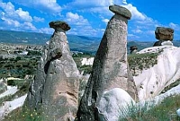
as a result of their violent eruptions. The natural effects of wind, water and
rain eroded this area into a spectacular, surrealist landscape of rock caves,
capped pinnacles and fretted ravines in colors ranging from warm tones of red
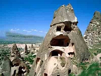
and gold to cool tones of green and gray. Dating back to 4000 BC; the earliest
people used to live in Goreme, known as Cappadocia, in dwellings dug into the
rock. Christianity came to the region, and chapels, churches and monasteries
were constructed in the rocks. At Derinkuyu, Mazi and Kaymakli, cities were
developed underground in order for the inhabitants to hide from raiders. There
is another underground city -Ozkonak- which is also open to the public. They are
really amazing to visit, and give a sense of the way people must have felt while
living underground. Urgup, 20 kms east of Nevsehir, is a lively tourist center
and has all the characteristics of the region. Besides this, it is the center of
a wine producing region and every year in October an International Wine Festival
is held. It is an excellent place to stay to tour the sights in daytime and to
find amusement in discos and bars at night. In Urgup you can see how people once
lived in houses carved into the rock along the narrow streets. This is a good
place for buying carpets and kilims, as many varieties are offered. Pancarlik
Valley, the Mustafapasa (Sinassos) and Cemil villages, with their traditional
stone houses, the Taskinpasa and Sahinefendi villages where the 2th century
Kirksehitler Church is located, and the Devrent and Catalkaya Valleys are famous
for their fairy chimneys. The Goreme Open Air Museum, 8 km northwest of Urgup,
is a monastic complex of rock churches
 and chapels decorated with frescoes. The
churches of Elmali, St. Basil, St. Barbara, Yilanli, Karanlik, Carikli, and
Tokali are of particular interest and their frescoes are very well preserved.
Many pilgrims still visit the churches. The cities of Goreme and Uchisar provide
a bewitching scenery of cones and chimney formations. Uchisar Fortress is the
highest point and the view from its top is enchanting. In Cavusin you will find
the monastery of St. John the Baptist. The attractive town of Avanos is famous
for its handicrafts, especially pottery, and you may try this craft yourself in
one of the many studios. Soganli has a picturesque beauty with dozens of
chapels, churches, halls and tombs. The Byzantine development of fresco art can
be observed from the 8th to the 13th centuries in Soganli. The town of Ortahisar
is carved out of rock. The churches in the Balkan Valley are some of the oldest.
Kizilcukur Valley is strikingly beautiful during sunset. You should not miss
that marvelous picture. Cappadocia is a land which seems to be a fantasy. Words
are useless to describe the beauty and charm of the region; you must experience
it for yourself. It will certainly take a particular place in your memories and
in your photograph album.
text reference : www.anatolia.com
Local Weather Condition
| Latitude(° ' ) | Longitude(° ' ) | PoR (year) | E (m) | M C (0-10) | M H (%) | MRF (mm) | DwR | PWD | MWS (m/sn) | H T (°C) | M Tmax (°C) | M Tmin (°C) | L T (°C) | M T (°C) | DwS | DwoS |
|---|---|---|---|---|---|---|---|---|---|---|---|---|---|---|---|---|
| 38 38 | 34 43 | 16 | 1260 | 6.5 | 64 | 46 | 12.5 | WSW | 3.8 | 24.4 | 9.9 | 0.4 | -13.7 | 4.9 | 2.5 | 10.9 |
| PoR : Period of Record (year) | E : Elevation (m) | M C : Mean Cloud (0-10) | M H : Mean Humidity (%) |
| M R F : Mean Rain Fall (mm) | DwR : Days with rain | PWD : Prevail wind direction | MWS : Mean wind speed (m/sn) |
| H T : Highest T (°C) | M Tmax : Mean Tmax (°C) | M Tmin : Mean Tmin (°C) | L T : Lowest T (°C) |
| M T : Mean T (°C) | DwS : Days with Sun | DwoS : Days without Sun |