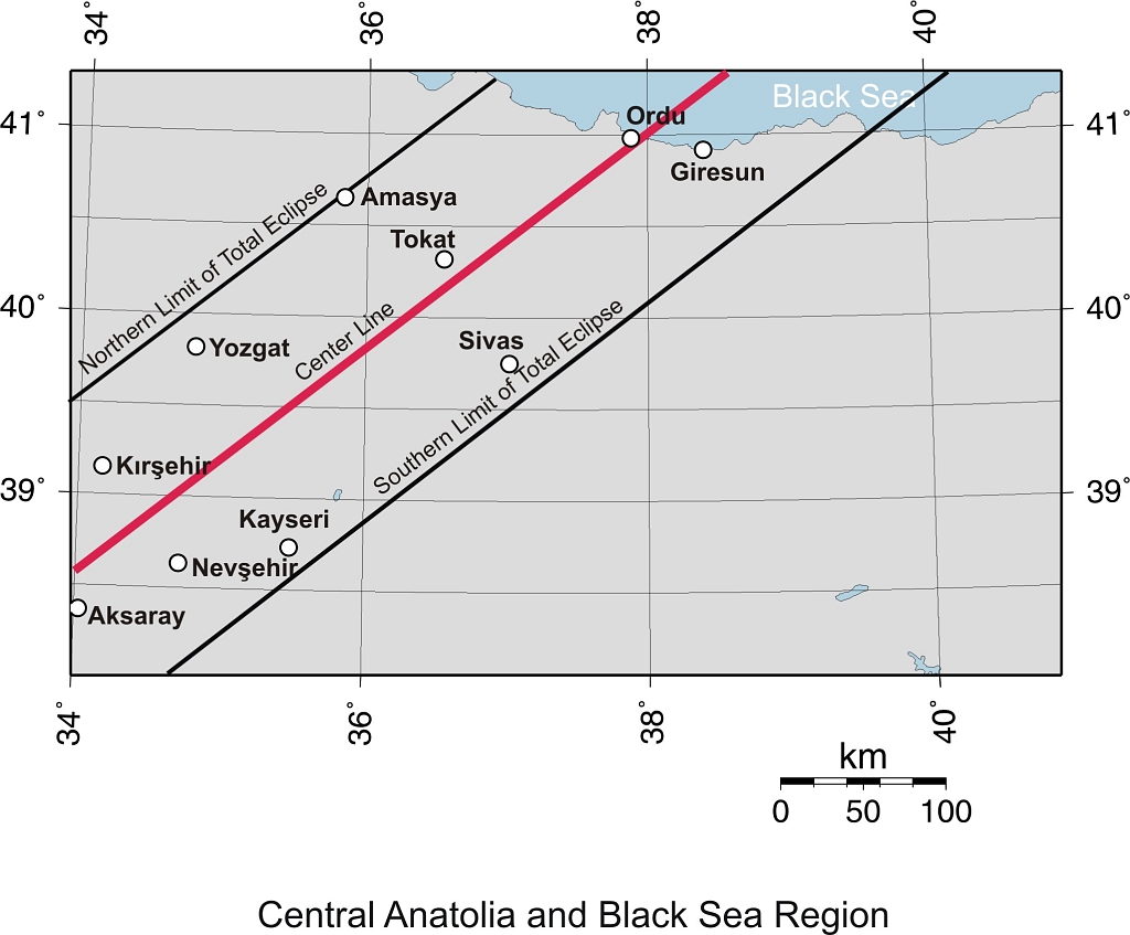
|
KAYSERI |
City Information
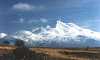
 An ever snowy
peak, rising magnificently over the Central Anatolian plateau, is Mount Erciyes
(3196 m), an extinct volcano. Those who visit Kayseri, the city situated at the
skirt of this mountain, first view this majestic sight. Then as they move
towards the inner city, they will be amazed by the appearance of elegant
minarets and domes of mosques, and the high city walls. 314 kms from Ankara,
this province forms a composition of history and nature, and possesses many
special features both as an ancient site and as a present-day tourist center.
The city is full of many old Turkish baths, fountains, tombs, inns, mosques, and
medresses. Mount Erciyes is the most outstanding feature in this region, not
only with its fascinating scenery but also with the opportunities it offers for
winter sports. It is a beautiful ski-resort with many facilities, and there also
exist several areas suitable for mountaineering. At the foot of Mount Erciyes
are the Sultan Marshes, 50 kms south of Kayseri. Birds of 130 species are to be
found here and it is an interesting and lovely spot for bird watchers. Besides
the beauties granted by nature, Kayseri enjoys the many gifts of history, being
a settlement area approximately 5000 years old. The city has played different
roles throughout its long past. By the 2nd millenium BC, the district was one of
the commercial centers of the Hittites. The towns of Kultepe and Karahoyuk of
Kanesh were two of these trade cities, named as "Karums" in that period. In the
later ages, the city constituted one of the cornerstones of Cappadocia after
which it became a center of Christianity. In the 6th century AD, it was occupied
by the Byzantines who surrounded the city with high walls. Later saw the age of
Seljuk rule, during which the area was filled with numerous monumental works.
With respect to the historical signs which have remained from all these periods,
the Huand (Mahperi) Hatun Mosque and Medresse, and the Mahperi Hatun Mausoleum
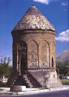
are of importance, each dating back to the 13th century. "Kumbets", which are
circular tombs with domed or conical roofs, named Doner, Cifte and Sircali, are
also attractive places to see having distinctively fine decoration.
An ever snowy
peak, rising magnificently over the Central Anatolian plateau, is Mount Erciyes
(3196 m), an extinct volcano. Those who visit Kayseri, the city situated at the
skirt of this mountain, first view this majestic sight. Then as they move
towards the inner city, they will be amazed by the appearance of elegant
minarets and domes of mosques, and the high city walls. 314 kms from Ankara,
this province forms a composition of history and nature, and possesses many
special features both as an ancient site and as a present-day tourist center.
The city is full of many old Turkish baths, fountains, tombs, inns, mosques, and
medresses. Mount Erciyes is the most outstanding feature in this region, not
only with its fascinating scenery but also with the opportunities it offers for
winter sports. It is a beautiful ski-resort with many facilities, and there also
exist several areas suitable for mountaineering. At the foot of Mount Erciyes
are the Sultan Marshes, 50 kms south of Kayseri. Birds of 130 species are to be
found here and it is an interesting and lovely spot for bird watchers. Besides
the beauties granted by nature, Kayseri enjoys the many gifts of history, being
a settlement area approximately 5000 years old. The city has played different
roles throughout its long past. By the 2nd millenium BC, the district was one of
the commercial centers of the Hittites. The towns of Kultepe and Karahoyuk of
Kanesh were two of these trade cities, named as "Karums" in that period. In the
later ages, the city constituted one of the cornerstones of Cappadocia after
which it became a center of Christianity. In the 6th century AD, it was occupied
by the Byzantines who surrounded the city with high walls. Later saw the age of
Seljuk rule, during which the area was filled with numerous monumental works.
With respect to the historical signs which have remained from all these periods,
the Huand (Mahperi) Hatun Mosque and Medresse, and the Mahperi Hatun Mausoleum
are of importance, each dating back to the 13th century. "Kumbets", which are
circular tombs with domed or conical roofs, named Doner, Cifte and Sircali, are
also attractive places to see having distinctively fine decoration.
 In the town
of Develi are the old Seljuk buildings of Ulu Mosque, Seyid-I Serif, and Develi
tomb; on the Sivas road 46 kms north of Kayseri is the Sultan Han, a
caravanserai constructed during the reign of Alaeddin Keykubat. Acting as a
learning center during the Seljuk period, the city possesses many medresses,
which were the theological schools of the time. Sahabiye Medresse is beautiful
with its original monumental portal, and the Cifte Medresse is another, carrying
the title of the first medieval school of anatomy. Notable sites of the province
of Kayseri also include the Haci Kilic Mosque of 1249, the Kosk Medresse of the
Mongol period, the Archeological Museum, the Ethnographical Museum and the
"bedesten" (covered bazaar). Among the many natural attractions are a lot of
mineral and hot springs. Noteworthy specialties of the region are the knotted
silk carpets (Bunyan), and wool rugs of Yahyali, which make beautiful souvenirs;
and the delicious foods, "sucuk", "salam" and "pastirma" (sun-dried beef covered
with a spicy paste).
In the town
of Develi are the old Seljuk buildings of Ulu Mosque, Seyid-I Serif, and Develi
tomb; on the Sivas road 46 kms north of Kayseri is the Sultan Han, a
caravanserai constructed during the reign of Alaeddin Keykubat. Acting as a
learning center during the Seljuk period, the city possesses many medresses,
which were the theological schools of the time. Sahabiye Medresse is beautiful
with its original monumental portal, and the Cifte Medresse is another, carrying
the title of the first medieval school of anatomy. Notable sites of the province
of Kayseri also include the Haci Kilic Mosque of 1249, the Kosk Medresse of the
Mongol period, the Archeological Museum, the Ethnographical Museum and the
"bedesten" (covered bazaar). Among the many natural attractions are a lot of
mineral and hot springs. Noteworthy specialties of the region are the knotted
silk carpets (Bunyan), and wool rugs of Yahyali, which make beautiful souvenirs;
and the delicious foods, "sucuk", "salam" and "pastirma" (sun-dried beef covered
with a spicy paste).
text reference : www.anatolia.com
Local Weather Condition
| Latitude(° ' ) | Longitude(° ' ) | PoR (year) | E (m) | M C (0-10) | M H (%) | MRF (mm) | DwR | PWD | MWS (m/sn) | H T (°C) | M Tmax (°C) | M Tmin (°C) | L T (°C) | M T (°C) | DwS | DwoS |
|---|---|---|---|---|---|---|---|---|---|---|---|---|---|---|---|---|
| 38 44 | 35 29 | 39 | 1068 | 6.5 | 70 | 38.5 | 13.3 | S | 2.3 | 28.6 | 10.8 | -1.7 | -26.6 | 4.4 | 3.3 | 11.6 |
| PoR : Period of Record (year) | E : Elevation (m) | M C : Mean Cloud (0-10) | M H : Mean Humidity (%) |
| M R F : Mean Rain Fall (mm) | DwR : Days with rain | PWD : Prevail wind direction | MWS : Mean wind speed (m/sn) |
| H T : Highest T (°C) | M Tmax : Mean Tmax (°C) | M Tmin : Mean Tmin (°C) | L T : Lowest T (°C) |
| M T : Mean T (°C) | DwS : Days with Sun | DwoS : Days without Sun |
![]()