|
AKSARAY |
City Information
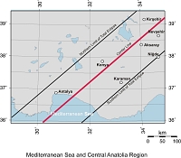
 Aksaray is a
center in Cappadocia, in the Central Anatolian region. The province has many
things to show in addition to wonderful surroundings. There are important
historical buildings from Seljuk times, mostly from the 14th century, such as
the Ulu Mosque and the Kizil (Egri) Minaret. The brickwork of the Kizil Minaret
is elaborate. The Sultanhan caravanserai built by the Seljuk Sultan Alaeddin
Keykubat is well-preserved, and the Agzikarahan caravanserai is the second
important and famous monument from the Seljuk period, both built on the Silk
Road.
Aksaray possesses the most frequently visited regions of Cappadocia, all of
display which natural beauties mingled with the mysticism of history. Viransehir
(Nora), which was the military center of Byzantines and Romans because of its
strategic position, carries historical remains from Roman and Byzantine times.
Ihlara is a 14 kms long fascinating canyon, formed by the Melendiz River. In
this valley can be found Byzantine rock chapels used by the early Christians,
similar to the ones at Göreme valley, cut into the canyon walls and decorated
with frescoes. From these chapels the Agacalti (Daniel) Church,
 the Yilanli
(Apocalypse) Church, the Sümbüllü (Hyacinth) Church, the Purenliseki Church, and
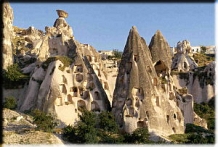
St. Georges Church are the most interesting ones. In the Güzelyurt valley, there
are dwellings from the prehistoric periods and they are in an underground city
form. In addition to these there are chapels and buildings carved into the rock.
The Manastir valley, and the Sivisli Church which is one of the most interesting
churches in the area, are the other attractive places.
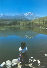
One of the most spectacular views in Aksaray is the Hasan mountain, an ancient
volcano, rising from the flatlands of Anatolia and touching some 3,200m
(10,000ft approximately). It is a great spot for mountain sports fans such as
climbers and trekkers.
Accompanying these you will also find guest houses, restaurants and good hotels
in the region.
text reference : www.anatolia.com
Local Weather Condition
| Latitude | Longitude | PoR | E | M C | M H | MRF | DwR | PWD | MWS | H T | M Tmax | M Tmin | L T | M T | DwS | DwoS |
|---|---|---|---|---|---|---|---|---|---|---|---|---|---|---|---|---|
| (° ' ) | (° ' ) | (year) | (m) | (0-10) | (%) | (mm) | (m/sn) | (°C) | (°C) | (°C) | (°C) | (°C) | ||||
| 38 22 | 34 02 | 37 | 980 | 5.8 | 68 | 42 | 9.1 | SW | 3.1 | 24.5 | 12.6 | 2.1 | -8.4 | 6.8 | 5 | 7.8 |
| PoR : Period of Record (year) | E : Elevation (m) | M C : Mean Cloud (0-10) | M H : Mean Humidity (%) |
| M R F : Mean Rain Fall (mm) | DwR : Days with rain | PWD : Prevail wind direction | MWS : Mean wind speed (m/sn) |
| H T : Highest T (°C) | M Tmax : Mean Tmax (°C) | M Tmin : Mean Tmin (°C) | L T : Lowest T (°C) |
| M T : Mean T (°C) | DwS : Days with Sun | DwoS : Days without Sun |